At Elydium, we know that navigating the world of bus data can feel as complex as finding your way through a busy city’s underground system. That’s why we’ve created our unique metro-style map – a visual guide to the Bus Data Network that helps you understand how different data exchange formats and data types connect across the industry:
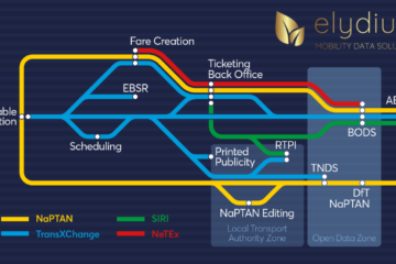
Just like a metro map, our diagram lays out the main “lines” of data exchange: NaPTAN, SIRI, TransXChange and NeTEx, each representing a different standard for sharing information. Along these lines, you’ll find “stations” representing software systems where data is created, modified or used. The interchanges show the crucial points at which data needs to be matched between different data types, signifying the importance of these functions within your business.
Whether you’re a transport operator or authority, our map is designed to demystify the complexities of bus data and help you choose the right route for your journey to better data.
Ready to get started? Contact us to learn more about our data solutions and how we can help you navigate the Bus Data Network with confidence.